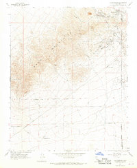
1967 Map of Johannesburg
USGS Topo · Published 1968About this map
Yellow Aster Mine dominates the northern landscape of this 1967 survey, serving as a primary focal point for the mining history of the Rand Mountains. The neighboring settlements of Randsburg and Johannesburg are shown in detail, positioned near the Kern and San Bernardino County line. The terrain transitions from the high elevations of Government Peak and Sidney Peak down toward the southern desert flats, where the California City Corporate Boundary marks the early northern expansion of California City. A network of infrastructure, including the Mojave Randsburg Road and a dedicated Radio Facility, illustrates the mid-century industrial and civic footprint in the High Desert. The presence of numerous Trenches and unnamed Mines scattered across Fiddler Gulch and the surrounding slopes provides a clear record of intensive resource extraction in the region.
Find a feature on this map
22 named features on this map. Tap any name to fly to it.
Don’t see what you’re looking for? This feature index may not catch every label — zoom into the map to look around manually.
Map Details
Editions of this 1967 Johannesburg Map
2 editions found
Other maps of this area

1903 · Randsburg
USGS Topo · 1:62,500

1911 · Randsburg
USGS Topo · 1:62,500

1912 · Randsburg
USGS Topo · 1:62,500

1915 · Searles Lake
USGS Topo · 1:250,000

1943 · Saltdale
USGS Topo · 1:62,500

1943 · Castle Butte
USGS Topo · 1:62,500

1947 · Castle Butte
USGS Topo · 1:50,000

1947 · Trona
USGS Topo · 1:250,000

1948 · Trona
USGS Topo · 1:250,000

1953 · Trona
USGS Topo · 1:250,000