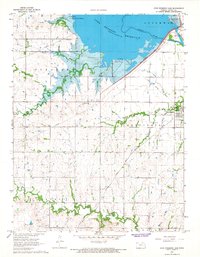
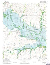
1966 Map of John Redmond Dam
USGS Topo · Published 1968About this map
John Redmond Reservoir dominates the northern landscape of this mid-1960s survey, representing a significant transformation of the Neosho River valley. The massive John Redmond Dam anchors the eastern side of the pool, while the Flint Hills National Wildlife Refuge preserves the wetlands at the reservoir's upper reaches. In the southeast, the town of Burlington sits at a historic crossroads where the Atchison Topeka and Santa Fe Railroad meets the river. Rural history is well-preserved through numerous family burial sites, including Bailey Cem and Baker Cem, which remain as markers of the earlier settlement patterns across Pleasant and Burlington townships. An Old Grade reflects an earlier transportation alignment that predates the modern infrastructure, offering a glimpse into the evolving land use around the Neosho valley before the flood control projects were completed.
Find a feature on this map
29 named features on this map. Tap any name to fly to it.
Don’t see what you’re looking for? This feature index may not catch every label — zoom into the map to look around manually.
Map Details
Editions of this 1966 John Redmond Dam Map
This is the sole edition of this map. No revisions or reprints were ever made.
Other maps of this area

1885 · Burlington
USGS Topo · 1:125,000

1894 · Burlington
USGS Topo · 1:125,000

1947 · Lawrence
USGS Topo · 1:250,000

1950 · Lawrence
USGS Topo · 1:250,000

1956 · Lawrence
USGS Topo · 1:250,000

1961 · Lawrence
USGS Topo · 1:250,000
1967 · Gridley SE
USGS Topo · 1:24,000
1967 · Gridley NW
USGS Topo · 1:24,000
1967 · Gridley
USGS Topo · 1:24,000
1970 · Hartford
USGS Topo · 1:24,000