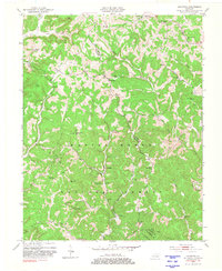
1953 Map of Johnetta
USGS Topo · Published 1981About this map
Daniel Boone National Forest covers much of this landscape, where the boundary between Jackson and Rockcastle counties winds through a network of creeks and ridges. The area is defined by small rural hubs such as Johnetta, Climax, and Goochland, which served as local centers for agricultural and timber life in the early 1950s. The topographic detail reveals a community-focused landscape marked by numerous one-room schoolhouses like the Owen Allen Sch and Pine Grove Sch, alongside country churches including Corinth Ch and New Hope Ch.
Find a feature on this map
51 named features on this map. Tap any name to fly to it.
Don’t see what you’re looking for? This feature index may not catch every label — zoom into the map to look around manually.
Map Details
Editions of this 1953 Johnetta Map
4 editions found
Other maps of this area

1892 · Richmond
USGS Topo · 1:125,000

1893 · London
USGS Topo · 1:125,000

1897 · Richmond
USGS Topo · 1:125,000

1897 · London
USGS Topo · 1:125,000

1952 · Alcorn
USGS Topo · 1:24,000

1952 · Berea
USGS Topo · 1:24,000

1952 · Bighill
USGS Topo · 1:24,000

1953 · Johnetta
USGS Topo · 1:24,000

1953 · Sandgap
USGS Topo · 1:24,000

1953 · Wildie
USGS Topo · 1:24,000