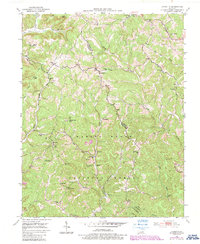
1953 Map of Johnetta
USGS Topo · Published 1987About this map
Daniel Boone National Forest dominates the southern half of this landscape, where the rugged terrain of Jackson and Rockcastle counties meet. The mid-century topography reflects a rural economy transitioning between subsistence farming and industrial extraction, evidenced by the numerous small Strip Mines appearing alongside established communities. Scattered settlements like Johnetta, Climax, and Threelinks are connected by narrow roads winding through ridges and gaps such as Poplar Gap.
Find a feature on this map
48 named features on this map. Tap any name to fly to it.
Don’t see what you’re looking for? This feature index may not catch every label — zoom into the map to look around manually.
Map Details
Editions of this 1953 Johnetta Map
4 editions found
Other maps of this area

1892 · Richmond
USGS Topo · 1:125,000

1893 · London
USGS Topo · 1:125,000

1897 · Richmond
USGS Topo · 1:125,000

1897 · London
USGS Topo · 1:125,000

1952 · Alcorn
USGS Topo · 1:24,000

1952 · Berea
USGS Topo · 1:24,000

1952 · Bighill
USGS Topo · 1:24,000

1953 · Johnetta
USGS Topo · 1:24,000

1953 · Sandgap
USGS Topo · 1:24,000

1953 · Wildie
USGS Topo · 1:24,000