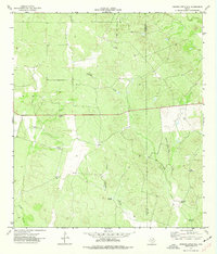
1974 Map of Johnnie Little Hill
USGS Topo · Published 1977About this map
Johnnie Little Hill rises as the central landmark in this 1974 survey of the South Texas landscape, situated along the boundary of Zavala Co and Frio Co. The area is defined by a sparse but critical water network, where seasonal drainages like Fight and Holler Creek and Yoledigo Creek carve through the brush country. The map reveals the infrastructure of mid-century cattle ranching, marked by a systematic placement of named water sources. From the clusters at Three Leg Windmills to isolated points like North Windmill and Mare Trap Windmill, these features indicate a landscape carefully managed for livestock. A solitary Drill Hole and a Gravel Pit suggest the extraction of resources from the dry Texas soil during this era.
Find a feature on this map
16 named features on this map. Tap any name to fly to it.
Don’t see what you’re looking for? This feature index may not catch every label — zoom into the map to look around manually.
Map Details
Editions of this 1974 Johnnie Little Hill Map
This is the sole edition of this map. No revisions or reprints were ever made.
Other maps of this area

1898 · Uvalde
USGS Topo · 1:125,000

1899 · Uvalde
USGS Topo · 1:125,000

1928 · Frio Town
USGS Topo · 1:62,500

1942 · Divot
USGS Topo · 1:62,500

1953 · Crystal City
USGS Topo · 1:250,000

1954 · San Antonio
USGS Topo · 1:250,000

1955 · Crystal City
USGS Topo · 1:250,000

1956 · Divot
USGS Topo · 1:62,500

1957 · San Antonio
USGS Topo · 1:250,000

1957 · Batesville
USGS Topo · 1:62,500