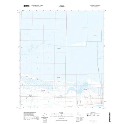
2020 Map of Johnson Bayou
USGS Topo · Published 2020About this map
Johnson Bayou and its surrounding wetlands occupy a landscape defined by an intricate network of coastal ridges and man-made waterways along the Gulf of Mexico. The area is characterized by long, linear terrain features such as Smith Ridge, Junius Ridge, and Salt Work Ridge, which provided elevated ground for early settlement and cemeteries in this marshy environment. Numerous drainage and industrial channels, including the Burton-Sutton Canal and the Magnolia Vacuum Canal, cut through the lowlands, reflecting the regional history of water management and oil field access via the Cameron Meadows Oil Field Rd. For genealogists and local historians, the presence of Peveto Cem, Head of the Hollow Cem, and Smith Ridge Cem offers specific points of interest for tracing family roots in this isolated corner of Cameron Parish. The geography centers on Hamilton Lake and the various bayous that snake toward the coast, illustrating the constant movement of water through the Louisiana wetlands.
Find a feature on this map
33 named features on this map. Tap any name to fly to it.
Don’t see what you’re looking for? This feature index may not catch every label — zoom into the map to look around manually.
Map Details
Editions of this 2020 Johnson Bayou Map
This is the sole edition of this map. No revisions or reprints were ever made.
Other maps of this area

1932 · Sabine Pass NE
USGS Topo · 1:31,680

1932 · Port Arthur NE
USGS Topo · 1:31,680

1934 · Johnsons Bayou
USGS Topo · 1:24,000

1934 · Peveto Beach
USGS Topo · 1:24,000

1934 · Greens Bayou
USGS Topo · 1:24,000

1934 · Five Lakes
USGS Topo · 1:24,000

1935 · Peveto Beach
USGS Topo · 1:31,680

1935 · Five Lakes
USGS Topo · 1:31,680

1935 · Greens Bayou
USGS Topo · 1:31,680

1935 · Johnsons Bayou
USGS Topo · 1:31,680