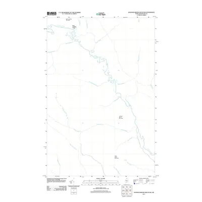
2011 Map of Johnson Brook Mountain
USGS Topo · Published 2011About this map
The Little Black River winds through the remote northern Maine timberlands in this 2011 survey, defining a landscape shaped by water and elevation. The terrain is anchored by a series of significant peaks, including Boat Landing Mountain, Johnson Brook Mountain, and Kelly Brook Mountain, which overlook a dense network of drainages. This area is characterized by its complex system of tributary brooks, such as Knowland Brook, Meadow Brook, and Carrie Bogan Brook, which feed into the primary river channel. A small outpost at Boat Landing Camp serves as a lone named settlement marker in this otherwise uninhabited forest. The presence of the Al 11 road corridor provides the primary navigational artery through the south-central portion of the map, while the rest of the quadrangle remains dominated by natural features and logging-era place names like Poplar Island Brook and Oxbow Brook.
Find a feature on this map
20 named features on this map. Tap any name to fly to it.
Don’t see what you’re looking for? This feature index may not catch every label — zoom into the map to look around manually.
Map Details
Editions of this 2011 Johnson Brook Mountain Map
This is the sole edition of this map. No revisions or reprints were ever made.
Other maps of this area

1930 · Allagash
USGS Topo · 1:48,000

1933 · Allagash
USGS Topo · 1:62,500

1955 · Rocky Mountain
USGS Topo · 1:62,500

1955 · Rocky Brook
USGS Topo · 1:62,500

1955 · Beau Lake
USGS Topo · 1:62,500

1962 · Edmundston
USGS Topo · 1:250,000
1986 · Big Rapids
USGS Topo · 1:24,000
1986 · Allagash
USGS Topo · 1:24,000

1987 · Beau Lake
USGS Topo · 1:24,000
1987 · Johnson Brook Mountain
USGS Topo · 1:24,000