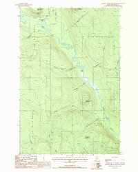
1987 Map of Johnson Brook Mountain
USGS Topo · Published 1987About this map
The Little Black River meanders through the heart of this North Woods territory, defining the drainage patterns and physical orientation of a heavily forested landscape in northern Maine. The terrain is dominated by prominent elevations including Johnson Brook Mountain, Boat Landing Mountain, and Hafey Mountain. In the late 1980s, the area remained largely undeveloped, characterized by a complex network of private logging roads and numerous tributaries such as Carrie Bogan Brook and Meadow Brook that feed into the primary river system. A single human landmark, the Boat Landing Camp, sits near the northern bend of the river, while to the south, the Little Black River passes Poplar Island before entering the township of Allagash. The map documents the intricate survey lines of the Unorganized Territory, including townships T 18 R 12 W E L S and T 18 R 11 W E L S, reflecting the region's history of timber management and remote wilderness use.
Find a feature on this map
23 named features on this map. Tap any name to fly to it.
Don’t see what you’re looking for? This feature index may not catch every label — zoom into the map to look around manually.
Map Details
Editions of this 1987 Johnson Brook Mountain Map
This is the sole edition of this map. No revisions or reprints were ever made.
Other maps of this area

1930 · Allagash
USGS Topo · 1:48,000

1933 · Allagash
USGS Topo · 1:62,500

1955 · Rocky Mountain
USGS Topo · 1:62,500

1955 · Rocky Brook
USGS Topo · 1:62,500

1955 · Beau Lake
USGS Topo · 1:62,500

1962 · Edmundston
USGS Topo · 1:250,000
1986 · Big Rapids
USGS Topo · 1:24,000
1986 · Allagash
USGS Topo · 1:24,000

1987 · Beau Lake
USGS Topo · 1:24,000

1987 · Hafey Pond
USGS Topo · 1:24,000