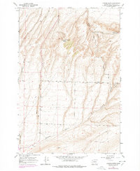
1964 Map of Johnson Butte
USGS Topo · Published 1978About this map
Johnson Butte and the surrounding high ground of Benton County dominate this 1964 survey, which was updated with 1976 aerial revisions. The landscape is defined by a network of drainage systems, including Zintel Canyon, Prospect Canyon, and Fourmile Canyon, cutting through the high plateaus. While much of the terrain is accessible only by a Jeep Trail, the map reveals early agricultural and utility infrastructure through features like a Storage Bin, a Pipeline, and the Radio Tower (KEPR).
Find a feature on this map
18 named features on this map. Tap any name to fly to it.
Don’t see what you’re looking for? This feature index may not catch every label — zoom into the map to look around manually.
Map Details
Editions of this 1964 Johnson Butte Map
2 editions found
Other maps of this area

1908 · Umatilla
USGS Topo · 1:125,000

1917 · Pasco
USGS Topo · 1:125,000

1953 · Pendleton
USGS Topo · 1:250,000

1953 · Walla Walla
USGS Topo · 1:250,000

1956 · Pendleton
USGS Topo · 1:250,000

1958 · Walla Walla
USGS Topo · 1:250,000

1962 · Hat Rock
USGS Topo · 1:24,000

1962 · Juniper
USGS Topo · 1:24,000

1962 · Umatilla
USGS Topo · 1:24,000
1964 · Johnson Butte
USGS Topo · 1:24,000