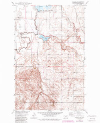
1949 Map of Johnson Lake
USGS Topo · Published 1989About this map
The Fort Peck Indian Reservation spans the western portion of this landscape, its boundary defined by the winding course of Big Muddy Creek. This 1949 survey, updated with photo-revisions in the late 1980s, captures the eastern edge of the reservation where it meets the wetlands of the Medicine Lake National Wildlife Refuge. The terrain is characterized by the hydrological network of Johnson Lake, Homestead Lake, and several seasonal watercourses including Sheep Creek and Sand Creek. A small Dam and a Gravel Pit appear as the few industrial or engineering modifications to the rural prairie. The map provides a detailed view of the Missouri River Basin development era, showing the relationship between protected federal lands and the intricate drainage patterns that define Roosevelt County.
Find a feature on this map
13 named features on this map. Tap any name to fly to it.
Don’t see what you’re looking for? This feature index may not catch every label — zoom into the map to look around manually.
Map Details
Editions of this 1949 Johnson Lake Map
2 editions found
Other maps of this area

1914 · Homestead
USGS Topo · 1:62,500

1947 · Rocky Point
USGS Topo · 1:24,000

1947 · Homestead
USGS Topo · 1:24,000

1948 · Homestead
USGS Topo · 1:24,000

1948 · Rocky Point
USGS Topo · 1:24,000

1948 · Medicine Lake
USGS Topo · 1:24,000

1948 · Fort Kipp
USGS Topo · 1:24,000

1949 · Fort Kipp
USGS Topo · 1:24,000
1949 · Medicine Lake
USGS Topo · 1:24,000

1949 · Johnson Lake
USGS Topo · 1:24,000