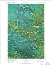
1970 Map of Johnson Landing NE
USGS Topo · Published 1973About this map
Koochiching State Forest dominates this northern landscape, captured in a detailed orthophotomap that blends traditional topographic contours with aerial photography. The terrain is defined by its drainage patterns, notably where the Cross River and Fork River navigate through the dense wooded cover of Koochiching County. Human activity is primarily oriented around forest management and passage, evidenced by the Winter Trail cutting through the central sections. High points in the canopy are monitored from the Denton Lookout Tower, a critical landmark for fire observation in this timber-rich region. Apart from a small Gravel Pit, the map reveals a largely undeveloped wilderness during the early 1970s, showcasing the intricate network of wetlands and forest stands that characterize the Minnesota borderlands.
Find a feature on this map
7 named features on this map. Tap any name to fly to it.
Don’t see what you’re looking for? This feature index may not catch every label — zoom into the map to look around manually.
Map Details
Editions of this 1970 Johnson Landing NE Map
This is the sole edition of this map. No revisions or reprints were ever made.
Other maps of this area

1919 · Happy Land
USGS Topo · 1:62,500

1919 · M
USGS Topo · 1:62,500

1954 · International Falls
USGS Topo · 1:250,000

1957 · International Falls
USGS Topo · 1:250,000

1958 · International Falls
USGS Topo · 1:250,000

1969 · Ericsburg SW
USGS Topo · 1:24,000

1970 · Johnson Landing SE
USGS Topo · 1:24,000

1970 · Littlefork SE
USGS Topo · 1:24,000

1970 · Littlefork SW
USGS Topo · 1:24,000
1970 · Nett Lake River West
USGS Topo · 1:24,000