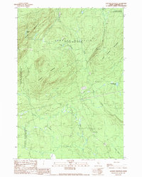
1989 Map of Johnson Mountain
USGS Topo · Published 1989About this map
Coburn Mountain and Johnson Mountain dominate this late-twentieth-century landscape in the North Maine Woods. The terrain is defined by a dense network of waterways including Twomile Brook, Salmon Stream, and the East Branch Cold Stream, which feeds into the larger Cold Stream. The small settlement of West Forks sits near the southern boundary within West Forks Plt, while the interior remains largely undeveloped forest punctuated by high-elevation water bodies like Mountain Ponds and Markham Pond. Evidence of local industry appears in the form of a Gravel Pit near a major Trans Line corridor, and a local landmark known as Cold Stream Falls highlights the area's natural drop in elevation. This document captures the remote character of Somerset County, showing a geography shaped by glaciation and timber-related access.
Find a feature on this map
22 named features on this map. Tap any name to fly to it.
Don’t see what you’re looking for? This feature index may not catch every label — zoom into the map to look around manually.
Map Details
Editions of this 1989 Johnson Mountain Map
This is the sole edition of this map. No revisions or reprints were ever made.
Other maps of this area

1905 · The Forks
USGS Topo · 1:62,500

1907 · The Forks
USGS Topo · 1:62,500

1921 · Brassua Lake
USGS Topo · 1:62,500

1922 · Long Pond
USGS Topo · 1:62,500

1923 · Brassua Lake
USGS Topo · 1:62,500

1924 · Long Pond
USGS Topo · 1:62,500

1925 · Pierce Pond
USGS Topo · 1:48,000

1927 · Pierce Pond
USGS Topo · 1:62,500

1944 · Brassua Lake
USGS Topo · 1:62,500

1944 · Long Pond
USGS Topo · 1:62,500
Featured Places
- West Forks, ME
- Upper Enchanted Township, ME
- Johnson Mountain Township, ME
- Chase Stream Township, ME
- Lower Enchanted Township, ME