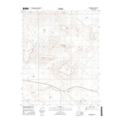
2017 Map of Johnson Park
USGS Topo · Published 2017About this map
Johnson Park anchors this corner of northeastern New Mexico, where the high-altitude terrain of Colfax County is defined by a series of prominent, flat-topped formations. This landscape is a complex system of drainage and relief, where Una de Gato Cr and Hunter Cr carve through deep canyons between massive landforms like Wilson Mesa and Juan Torres Mesa. The water management of the region is evident in features such as the Throttle Reservoir, while the southern reaches of the map transition into the distinct profiles of Haycock Buttes and Troyburg Mesa. The presence of several family-named landmarks, including Meloche Mesa and Buckhorn Mesa, suggests a history of ranching and settlement tied to these specific geological features. High-country watercourses like Little Water Cr and Archuleta Cr further illustrate the network of seasonal and perennial streams that have shaped the development of this high-desert environment.
Find a feature on this map
30 named features on this map. Tap any name to fly to it.
Don’t see what you’re looking for? This feature index may not catch every label — zoom into the map to look around manually.
Map Details
Editions of this 2017 Johnson Park Map
This is the sole edition of this map. No revisions or reprints were ever made.
Other maps of this area

1912 · Raton
USGS Topo · 1:62,500

1914 · Raton
USGS Topo · 1:62,500

1954 · Raton
USGS Topo · 1:250,000

1958 · Raton
USGS Topo · 1:250,000
1971 · Trinchera Pass
USGS Topo · 1:24,000

1971 · Kiowa
USGS Topo · 1:24,000
1971 · Dale Mountain
USGS Topo · 1:24,000
1971 · Hunter Mesa
USGS Topo · 1:24,000

1971 · Robinson Peak
USGS Topo · 1:24,000

1971 · Johnson Park
USGS Topo · 1:24,000