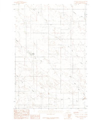
1983 Map of Johnson Reservoir
USGS Topo · Published 1983About this map
Johnson Reservoir serves as a central landmark in this high-plains landscape of Dawson County, where the intricate drainage system of the Yellowstone River basin is on full display. The topographic data reveals the complex branching of North Fork Deer Creek, Middle Fork Deer Creek, and South Fork Deer Creek as they carve through the arid terrain. The presence of a prominent Irrigation Ditch in the southeast corner indicates the vital role of water management in supporting local ranching or agricultural efforts during the early 1980s. To the north, Lower Sevenmile Creek cuts across the corner of the sheet, further illustrating the seasonal or intermittent waterways that define the hydrology of this Montana rangeland. This survey captures a specific moment in the rural development of the region, emphasizing the importance of even small water catchments in an otherwise dry environment.
Find a feature on this map
7 named features on this map. Tap any name to fly to it.
Don’t see what you’re looking for? This feature index may not catch every label — zoom into the map to look around manually.
Map Details
Editions of this 1983 Johnson Reservoir Map
This is the sole edition of this map. No revisions or reprints were ever made.
Other maps of this area

1909 · Glendive
USGS Topo · 1:250,000

1954 · Glendive
USGS Topo · 1:250,000

1957 · Glendive
USGS Topo · 1:250,000

1958 · Glendive
USGS Topo · 1:250,000

1972 · Poverty Flat West
USGS Topo · 1:24,000

1972 · Bloomfield
USGS Topo · 1:24,000

1972 · Stinking Coulee
USGS Topo · 1:24,000

1981 · Glendive
USGS Topo · 1:100,000

1982 · Circle
USGS Topo · 1:100,000

1983 · Johnson Reservoir NW
USGS Topo · 1:24,000