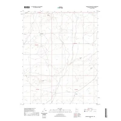
2020 Map of Johnson Trading Post
USGS Topo · Published 2020About this map
Johnson Trading Post serves as a central landmark in this high-desert landscape of Sandoval County, where the terrain is defined by a series of prominent mesas and seasonal watercourses. The area's character is shaped by the expansive San Isidro Valley and the steep escarpments of Ceja Pelo Mesa and Mesa Penistaja. Evidence of local habitation and land use is noted through the naming of specific sites such as Eddie Toledo and the critical water sources provided by Penistaja Spring and Max Lopez Spring. Transport through this arid region follows established paths like Ojo Encino Rd, while the natural drainage system of the San Isidro Wash and Penistaja Arroyo cuts through the sedimentary layers of Eagle Mesa and Fork Rock Mesa. This survey provides a clear view of the sparse settlement patterns and the traditional place names that define this portion of the Eastern Navajo Agency.
Find a feature on this map
23 named features on this map. Tap any name to fly to it.
Don’t see what you’re looking for? This feature index may not catch every label — zoom into the map to look around manually.
Map Details
Editions of this 2020 Johnson Trading Post Map
This is the sole edition of this map. No revisions or reprints were ever made.
Other maps of this area

1883 · Mt. Taylor
USGS Topo · 1:250,000

1886 · Mt. Taylor
USGS Topo · 1:250,000

1889 · Largo
USGS Topo · 1:250,000

1892 · Mt. Taylor
USGS Topo · 1:250,000

1895 · Largo
USGS Topo · 1:250,000

1899 · Mt. Taylor
USGS Topo · 1:250,000

1954 · Aztec
USGS Topo · 1:250,000

1958 · Aztec
USGS Topo · 1:250,000

1958 · Albuquerque
USGS Topo · 1:250,000
1961 · Ojo Encino Mesa
USGS Topo · 1:24,000