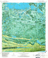
1982 Map of Johnsons Bayou
USGS Topo · Published 1982About this map
Johnsons Bayou anchors this coastal landscape where the land breaks into a series of long, linear cheniers rising above the surrounding marsh. These ridges, including Smith Ridge, Blue Buck Ridge, and Junius Ridge, provided the only stable ground for settlement and cemeteries in this part of Cameron Parish. Local genealogy is well-represented by the Smith Ridge Cem, Peveto Cem, and Head of the Hollow Cem, alongside the Our Lady of Assumption Ch and the local Johnsons Bayou High Sch. North of the settlement, the Sabine National Wildlife Refuge covers a vast portion of the wetlands, which are crisscrossed by the Starks South Canal and numerous pipelines. The industrial footprint of the early 1980s is visible in the Burton Oil Field and Cameron Meadows Oil and Gas Field, illustrating the economic drivers of the Gulf coast during this era.
Find a feature on this map
24 named features on this map. Tap any name to fly to it.
Don’t see what you’re looking for? This feature index may not catch every label — zoom into the map to look around manually.
Map Details
Editions of this 1982 Johnsons Bayou Map
This is the sole edition of this map. No revisions or reprints were ever made.
Other maps of this area

1932 · Sabine Pass NE
USGS Topo · 1:31,680

1932 · Port Arthur NE
USGS Topo · 1:31,680

1934 · Johnsons Bayou
USGS Topo · 1:24,000

1934 · Peveto Beach
USGS Topo · 1:24,000

1934 · Greens Bayou
USGS Topo · 1:24,000

1934 · Five Lakes
USGS Topo · 1:24,000

1935 · Peveto Beach
USGS Topo · 1:31,680

1935 · Five Lakes
USGS Topo · 1:31,680

1935 · Greens Bayou
USGS Topo · 1:31,680

1935 · Johnsons Bayou
USGS Topo · 1:31,680