
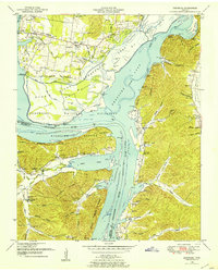
1936 Map of Johnsonville
USGS Topo · Published 1936About this map
Reynoldsburg Landing and the riverfront town of Johnsonville dominate this mid-1930s landscape along the Tennessee River. The area is a critical transit corridor, where the Nashville Chattanooga and St. Louis Railway crosses the water at the river's bend, linking the rail line to maritime traffic at Clarks Landing and Hartleys Landing. The map reveals a deeply localized community structure defined by numerous rural institutions, including Oak Grove Ch, Bowen Chapel, and the Link Sch. This documentation captures the river before its modern transformation, showing original shorelines around Reynoldsburg Island and Plant Island, along with a network of landings such as Dixie Landing and Faulks Landing that once served as vital points of trade and transport for the residents of Denver and the surrounding hollows.
Find a feature on this map
112 named features on this map. Tap any name to fly to it.
Don’t see what you’re looking for? This feature index may not catch every label — zoom into the map to look around manually.
Map Details
Editions of this 1936 Johnsonville Map
This is the sole edition of this map. No revisions or reprints were ever made.
Other maps of this area

1936 · Hurricane Mills
USGS Topo · 1:24,000

1936 · Camden
USGS Topo · 1:24,000

1936 · Big Sandy
USGS Topo · 1:24,000

1936 · Halls Creek
USGS Topo · 1:24,000

1936 · Harmon Creek
USGS Topo · 1:24,000

1936 · Rockport
USGS Topo · 1:24,000

1936 · Waverly
USGS Topo · 1:24,000

1936 · Hustburg
USGS Topo · 1:24,000

1949 · Harmon Creek
USGS Topo · 1:24,000
1949 · Hustburg
USGS Topo · 1:24,000