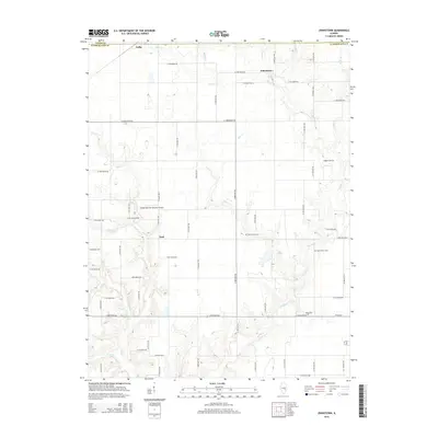
2015 Map of Johnstown
USGS Topo · Published 2015About this map
Johnstown and Trilla anchor the rural landscape of this 2015 Cumberland County survey, where the prairie topography is deeply incised by a dense network of watercourses. The drainage of Muddy Cr and its tributaries, including Bear Cr and Darkies Cr, dictates the placement of the region’s secondary roads and early homesteads. Genealogists will find a high concentration of small burial grounds scattered throughout the agricultural sections, including Higgins Cem, Drummond Cem, and the nearby Upper Berry Cem and Berry Cem. In the central portion of the map, the Cumberland Air Park RLA Airport sits near the small community of Neal, while to the east, Lake Louise provides a distinct water feature amidst the rolling terrain. The map also records the county boundary between Coles County and Cumberland County at its northern edge.
Find a feature on this map
40 named features on this map. Tap any name to fly to it.
Don’t see what you’re looking for? This feature index may not catch every label — zoom into the map to look around manually.
Map Details
Editions of this 2015 Johnstown Map
This is the sole edition of this map. No revisions or reprints were ever made.
Other maps of this area

1933 · Toledo
USGS Topo · 1:62,500

1934 · Mattoon
USGS Topo · 1:62,500

1937 · Mattoon
USGS Topo · 1:62,500

1938 · Toledo
USGS Topo · 1:62,500

1940 · Greenup
USGS Topo · 1:62,500

1943 · Greenup
USGS Topo · 1:62,500

1953 · Teutopolis
USGS Topo · 1:62,500

1958 · Decatur
USGS Topo · 1:250,000

1961 · Decatur
USGS Topo · 1:250,000
1984 · Neoga
USGS Topo · 1:24,000