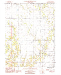
1984 Map of Johnstown
USGS Topo · Published 1985About this map
Johnstown sits at the heart of this rural landscape, characterized by the winding drainages of Muddy Creek and its many tributaries. The area is defined by its township structure, spanning portions of Cottonwood, Sumpter, and Pleasant Grove. Smaller settlements like Trilla in the northwest and Neal near the center provide local focal points for this agricultural region during the mid-1980s. A single Cem is marked near Trilla, serving as a point of interest for genealogists tracing local families.
Find a feature on this map
23 named features on this map. Tap any name to fly to it.
Don’t see what you’re looking for? This feature index may not catch every label — zoom into the map to look around manually.
Map Details
Editions of this 1984 Johnstown Map
This is the sole edition of this map. No revisions or reprints were ever made.
Other maps of this area

1933 · Toledo
USGS Topo · 1:62,500

1934 · Mattoon
USGS Topo · 1:62,500

1937 · Mattoon
USGS Topo · 1:62,500

1938 · Toledo
USGS Topo · 1:62,500

1940 · Greenup
USGS Topo · 1:62,500

1943 · Greenup
USGS Topo · 1:62,500

1953 · Teutopolis
USGS Topo · 1:62,500

1958 · Decatur
USGS Topo · 1:250,000

1961 · Decatur
USGS Topo · 1:250,000
1984 · Neoga
USGS Topo · 1:24,000