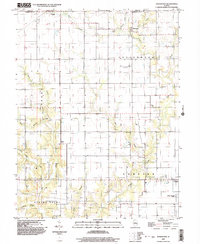
1998 Map of Johnstown
USGS Topo · Published 2003About this map
Trilla and Johnstown anchor the northern reaches of this Illinois landscape, where the prairie of Coles County meets Cumberland County. The terrain is defined by a dense network of drainage, where the headwaters of Muddy Creek and its many tributaries, such as Darkies Creek and Dicks Creek, carve subtle valleys into the agricultural plains. To the south, the village of Neal and the outskirts of Toledo mark the transition into Sumpter and Spring Point townships.
Find a feature on this map
26 named features on this map. Tap any name to fly to it.
Don’t see what you’re looking for? This feature index may not catch every label — zoom into the map to look around manually.
Map Details
Editions of this 1998 Johnstown Map
This is the sole edition of this map. No revisions or reprints were ever made.
Other maps of this area

1933 · Toledo
USGS Topo · 1:62,500

1934 · Mattoon
USGS Topo · 1:62,500

1937 · Mattoon
USGS Topo · 1:62,500

1938 · Toledo
USGS Topo · 1:62,500

1940 · Greenup
USGS Topo · 1:62,500

1943 · Greenup
USGS Topo · 1:62,500

1953 · Teutopolis
USGS Topo · 1:62,500

1958 · Decatur
USGS Topo · 1:250,000

1961 · Decatur
USGS Topo · 1:250,000
1984 · Neoga
USGS Topo · 1:24,000