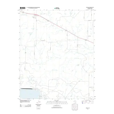
2012 Map of Jolly
USGS Topo · Published 2012About this map
The settlement of Jolly sits at the junction of State Spur 47 and FM-2393, serving as a central point in this North Texas landscape. The geography is defined by the winding course of the Little Wichita River and its tributaries, including Bennett Cr and Duck Cr. Agricultural and ranching interests are evident through named water bodies such as Triangle T Cattle Company Lake and Triangle T Lake Number 1, reflecting the region's long-standing cattle industry.
Find a feature on this map
32 named features on this map. Tap any name to fly to it.
Don’t see what you’re looking for? This feature index may not catch every label — zoom into the map to look around manually.
Map Details
Editions of this 2012 Jolly Map
This is the sole edition of this map. No revisions or reprints were ever made.
Other maps of this area

1954 · Wichita Falls
USGS Topo · 1:250,000

1956 · Sloop Creek
USGS Topo · 1:24,000

1956 · Henrietta
USGS Topo · 1:62,500

1957 · Wichita Falls East
USGS Topo · 1:62,500

1957 · Wichita Falls East
USGS Topo · 1:24,000

1958 · Wichita Falls
USGS Topo · 1:250,000

1963 · Deer Creek
USGS Topo · 1:24,000

1963 · Scotland
USGS Topo · 1:24,000
1968 · Bluegrove
USGS Topo · 1:24,000
1972 · Dean
USGS Topo · 1:24,000