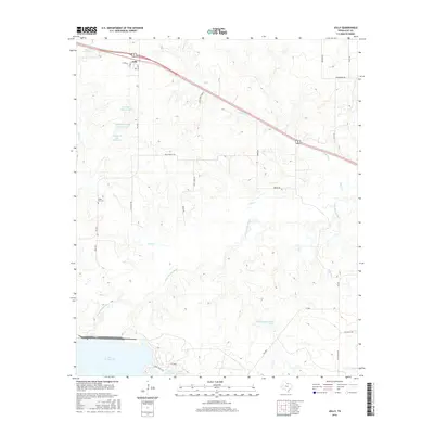
2016 Map of Jolly
USGS Topo · Published 2016About this map
Jolly sits in the northwest corner of this Clay County landscape, where the local road network of Dunn St and Gayle St meets the highway. The terrain is defined by the winding course of the Little Wichita River and the expansive northern reach of Lake Arrowhead in the south. This 2016 survey illustrates a modern ranching and water-management landscape, featuring numerous private reservoirs such as the Triangle T Cattle Company Lake and School Land Lake. Genealogists may find interest in the White Hill Cem, located west of Duck Cr. The map also documents large land holdings like the Bear Creek Ranch and specialized infrastructure such as the site on Gas Plant Rd, reflecting the region's contemporary agricultural and industrial character.
Find a feature on this map
33 named features on this map. Tap any name to fly to it.
Don’t see what you’re looking for? This feature index may not catch every label — zoom into the map to look around manually.
Map Details
Editions of this 2016 Jolly Map
This is the sole edition of this map. No revisions or reprints were ever made.
Other maps of this area

1954 · Wichita Falls
USGS Topo · 1:250,000

1956 · Sloop Creek
USGS Topo · 1:24,000

1956 · Henrietta
USGS Topo · 1:62,500

1957 · Wichita Falls East
USGS Topo · 1:62,500

1957 · Wichita Falls East
USGS Topo · 1:24,000

1958 · Wichita Falls
USGS Topo · 1:250,000

1963 · Deer Creek
USGS Topo · 1:24,000

1963 · Scotland
USGS Topo · 1:24,000
1968 · Bluegrove
USGS Topo · 1:24,000
1972 · Dean
USGS Topo · 1:24,000