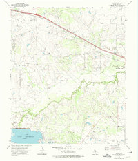
1972 Map of Jolly
USGS Topo · Published 1975About this map
The Fort Worth and Denver railroad cuts a sharp diagonal across this North Texas landscape, anchoring the small settlement of Jolly. In the early 1970s, the region’s economy is clearly defined by the heavy footprint of the Halsell Oil Field, where numerous oil wells and pipelines crisscross the terrain north of the Lake Arrowhead shoreline. The south end of the map is dominated by this expansive reservoir and the Wichita Falls Dam, which regulates the winding course of the Little Wichita River. Local history is preserved at the White Hill Cem and along the Old Railroad Grade in the southeast. The natural drainage of Bennett Creek and Duck Creek provides a contrast to the industrial infrastructure, illustrating the transition between the agricultural prairie and the active petroleum extraction zones of Clay County.
Find a feature on this map
12 named features on this map. Tap any name to fly to it.
Don’t see what you’re looking for? This feature index may not catch every label — zoom into the map to look around manually.
Map Details
Editions of this 1972 Jolly Map
This is the sole edition of this map. No revisions or reprints were ever made.
Other maps of this area

1954 · Wichita Falls
USGS Topo · 1:250,000

1956 · Sloop Creek
USGS Topo · 1:24,000

1956 · Henrietta
USGS Topo · 1:62,500

1957 · Wichita Falls East
USGS Topo · 1:62,500

1957 · Wichita Falls East
USGS Topo · 1:24,000

1958 · Wichita Falls
USGS Topo · 1:250,000

1963 · Deer Creek
USGS Topo · 1:24,000

1963 · Scotland
USGS Topo · 1:24,000
1968 · Bluegrove
USGS Topo · 1:24,000
1972 · Dean
USGS Topo · 1:24,000