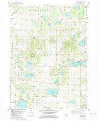
1981 Map of Jones
USGS Topo · Published 1982About this map
The Crane Pond State Game Area dominates this landscape in Cass County, preserving a complex of kettle lakes and wetlands in the early 1980s. Local settlements including Wakelee, Jones, and Corey are linked by rural routes like Dutch Settlement Rd and the Grand Trunk Western railroad. The map records numerous family and community landmarks essential for local history, from the Poe Cem and Lilly Cem to the Newberg Norton Bible Ch. Evidence of early industrial and recreational use is scattered throughout the terrain, including Streaters Millpond, various Gravel Pits, and established sites like Camp Eberhardt on Corey Lake and the Ski Area near Bald Hill.
Find a feature on this map
79 named features on this map. Tap any name to fly to it.
Don’t see what you’re looking for? This feature index may not catch every label — zoom into the map to look around manually.
Map Details
Editions of this 1981 Jones Map
This is the sole edition of this map. No revisions or reprints were ever made.
Other maps of this area

1914 · Three Rivers
USGS Topo · 1:62,500

1916 · Three Rivers
USGS Topo · 1:62,500

1922 · Schoolcraft
USGS Topo · 1:62,500

1943 · Three Rivers
USGS Topo · 1:62,500

1943 · Schoolcraft
USGS Topo · 1:62,500

1944 · Marcellus
USGS Topo · 1:62,500

1946 · Marcellus
USGS Topo · 1:62,500

1948 · Vandalia
USGS Topo · 1:62,500

1949 · Vandalia
USGS Topo · 1:62,500

1953 · Fort Wayne
USGS Topo · 1:250,000