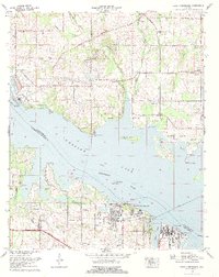
1976 Map of Jones Crossroads
USGS Topo · Published 1977About this map
Wheeler Lake and the Tennessee River dominate this 1970s landscape, illustrating the intersection of large-scale power infrastructure and long-standing rural settlements. The massive Browns Ferry Nuclear Plant stands as a significant industrial landmark on the north bank, complete with its Bio-thermal station and Meteorological tower. Across the water, the Decatur State Docks and a Filtration Plant mark the growing industrial footprint near the Limestone and Morgan County line.
Find a feature on this map
49 named features on this map. Tap any name to fly to it.
Don’t see what you’re looking for? This feature index may not catch every label — zoom into the map to look around manually.
Map Details
Editions of this 1976 Jones Crossroads Map
This is the sole edition of this map. No revisions or reprints were ever made.
Other maps of this area

1888 · Huntsville
USGS Topo · 1:125,000

1892 · Huntsville
USGS Topo · 1:125,000

1935 · Athens
USGS Topo · 1:24,000

1936 · Caddo
USGS Topo · 1:24,000

1936 · Decatur
USGS Topo · 1:24,000

1936 · Stewart Cross Roads
USGS Topo · 1:24,000

1936 · Ripley
USGS Topo · 1:24,000

1936 · Trinity
USGS Topo · 1:24,000

1936 · Hillsboro
USGS Topo · 1:24,000

1936 · Tanner
USGS Topo · 1:24,000