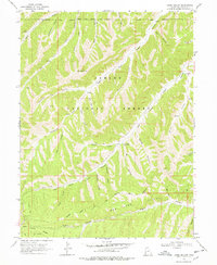
1968 Map of Jones Hollow
USGS Topo · Published 1978About this map
The Ashley National Forest dominates this section of the Uintah Basin, where a complex network of canyons and ridges defines the high-altitude landscape. The Indian Canyon Guard Station stands as a central point of activity within the Indian Canyon drainage, surrounded by numerous springs and narrow draws like Sterling Hollow and Jones Hollow. This survey preserves the exact path of the Old Indian Treaty Boundary Trail, which follows the high ground of the Indian Treaty Boundary, marking a significant historical line of demarcation across the peaks. To the south, the terrain drops dramatically at the Bad Land Cliffs, overlooking Argyle Canyon and the prominent Argyle Ridge. The map details a landscape transition from the timbered heights of Gray Head Peak to the deep incisions of Lake Canyon, providing a look at the backcountry infrastructure of fire trails and jeep tracks used during the late 1960s.
Find a feature on this map
36 named features on this map. Tap any name to fly to it.
Don’t see what you’re looking for? This feature index may not catch every label — zoom into the map to look around manually.
Map Details
Editions of this 1968 Jones Hollow Map
2 editions found
Other maps of this area

1885 · Uinta
USGS Topo · 1:250,000

1886 · Price River
USGS Topo · 1:250,000

1896 · Price River
USGS Topo · 1:250,000

1954 · Salt Lake City
USGS Topo · 1:250,000

1956 · Price
USGS Topo · 1:250,000

1958 · Salt Lake City
USGS Topo · 1:250,000

1960 · Salt Lake City
USGS Topo · 1:250,000

1960 · Price
USGS Topo · 1:250,000

1962 · Price
USGS Topo · 1:250,000
1962 · Buck Knoll
USGS Topo · 1:24,000