
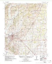
1958 Map of Jonesboro
USGS Topo · Published 1958About this map
Arkansas State College stands at the northern edge of Jonesboro, anchoring a landscape where the urban grid meets the agricultural reaches of Craighead County. This mid-century survey details the expansion of the regional hub, showing the proximity of Nettleton and the recreational space at Craighead Forest Park. The terrain is defined by a sophisticated water management network, including Main Ditch and numerous laterals such as Lateral No 3, reflecting the region's reliance on managed drainage for its farm economy.
Find a feature on this map
108 named features on this map. Tap any name to fly to it.
Don’t see what you’re looking for? This feature index may not catch every label — zoom into the map to look around manually.
Map Details
Editions of this 1958 Jonesboro Map
2 editions found
Other maps of this area

1932 · Walnut Ridge
USGS Topo · 1:62,500

1935 · Sedgwick
USGS Topo · 1:62,500

1935 · Walnut Ridge
USGS Topo · 1:62,500

1939 · Weiner
USGS Topo · 1:62,500

1939 · Jonesboro
USGS Topo · 1:62,500

1940 · Dee
USGS Topo · 1:62,500

1940 · Gainesville
USGS Topo · 1:62,500

1940 · Marmaduke
USGS Topo · 1:62,500

1941 · Leachville
USGS Topo · 1:62,500

1941 · Marked Tree
USGS Topo · 1:62,500