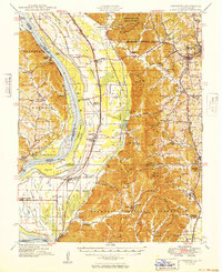
1949 Map of Jonesboro
USGS Topo · Published 1949About this map
The Mississippi River creates a dynamic border between Illinois and Missouri in this post-war survey, defined by complex waterways like Picayune Chute and Swiftsure Towhead. The western bottomlands, drained by the Running Lake Ditch and Clear Creek Ditch, contrast sharply with the rising timberlands of the Shawnee National Forest and Union County State Forest.
Find a feature on this map
119 named features on this map. Tap any name to fly to it.
Don’t see what you’re looking for? This feature index may not catch every label — zoom into the map to look around manually.
Map Details
Editions of this 1949 Jonesboro Map
This is the sole edition of this map. No revisions or reprints were ever made.
Other maps of this area

1918 · Altenburg
USGS Topo · 1:62,500

1920 · Jonesboro
USGS Topo · 1:62,500

1920 · Dongola
USGS Topo · 1:62,500

1922 · Carbondale
USGS Topo · 1:62,500

1922 · Cape Girardeau
USGS Topo · 1:62,500

1923 · Dongola
USGS Topo · 1:62,500

1923 · Jonesboro
USGS Topo · 1:62,500

1924 · Cape Girardeau
USGS Topo · 1:62,500

1924 · Alto Pass
USGS Topo · 1:62,500

1925 · Altenburg
USGS Topo · 1:62,500