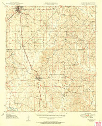
1950 Map of Jonesboro
USGS Topo · Published 1950About this map
Jonesboro serves as the primary hub of this North Louisiana landscape at the mid-century, where the Chicago Rock Island and Pacific railroad creates a north-south corridor through the timberlands. The map reveals a dense network of small rural communities and gathering places, including Dodson, Wyatt, and Gansville. Genealogists will find significant value in the distribution of country churches and schools, such as Harmony Grove Ch, Siloam Ch, and Gaars Mill Sch, which anchored local life between the creek drainages. To the south, the terrain descends toward the Dugdemona River and the shaded bottomlands of the Kisatchie National Forest, while fire towers like the Winona Lookout Tower monitor the surrounding forests. The abundance of named water bodies, including Caney Creek and Flat Creek, illustrates the complex drainage system defining the borders of Jackson and Winn parishes.
Find a feature on this map
44 named features on this map. Tap any name to fly to it.
Don’t see what you’re looking for? This feature index may not catch every label — zoom into the map to look around manually.
Map Details
Editions of this 1950 Jonesboro Map
2 editions found
Other maps of this area

1947 · Goldonna
USGS Topo · 1:62,500

1947 · Bienville
USGS Topo · 1:62,500

1949 · Calvin NE
USGS Topo · 1:31,680

1949 · Bienville
USGS Topo · 1:62,500

1949 · Jonesboro
USGS Topo · 1:62,500

1950 · Jonesboro
USGS Topo · 1:62,500

1950 · Winnfield
USGS Topo · 1:62,500

1951 · Winnfield
USGS Topo · 1:62,500

1953 · Chatham
USGS Topo · 1:62,500

1953 · Hodge
USGS Topo · 1:62,500