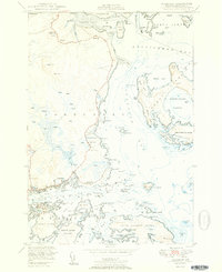
1951 Map of Jonesport
USGS Topo · Published 1951About this map
The maritime communities of Jonesport and West Jonesport sit prominently along the northern shore of Mooseabec Reach, a critical waterway for Maine’s coastal trade and fishing. This mid-century survey captures a landscape defined by its intricate shoreline, where family and community landmarks like the Library, Greenwood Cem, and Kelley School serve the local population. Across the reach, Beals island appears as a developed hub of maritime activity.
Find a feature on this map
135 named features on this map. Tap any name to fly to it.
Don’t see what you’re looking for? This feature index may not catch every label — zoom into the map to look around manually.
Map Details
Editions of this 1951 Jonesport Map
2 editions found
Other maps of this area

1918 · Machias
USGS Topo · 1:62,500

1921 · Great Wass Island
USGS Topo · 1:62,500

1921 · Columbia Falls
USGS Topo · 1:62,500

1921 · Columbia Falls
USGS Topo · 1:62,500

1941 · Columbia Falls
USGS Topo · 1:62,500

1941 · Machias
USGS Topo · 1:62,500

1942 · Columbia Falls
USGS Topo · 1:62,500

1948 · Jonesport
USGS Topo · 1:24,000
1948 · Columbia Falls
USGS Topo · 1:24,000

1948 · Roque Bluffs
USGS Topo · 1:24,000