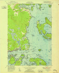
1951 Map of Jonesport
USGS Topo · Published 1951About this map
Jonesport and the island community of Beals anchor this coastal survey, illustrating the intricate relationship between Washington County settlements and the Gulf of Maine. The map details a maritime landscape defined by expansive reaches like Chandler Bay and the sheltered waters of Moose Alley Bay. Significant community infrastructure is visible, including the Library and the U S Coast Guard Reservation near Little Pond Beach. Local education and genealogy are represented by the Kelley School, Upper Bay District Sch, and Greenwood Cem.
Find a feature on this map
136 named features on this map. Tap any name to fly to it.
Don’t see what you’re looking for? This feature index may not catch every label — zoom into the map to look around manually.
Map Details
Editions of this 1951 Jonesport Map
2 editions found
Other maps of this area

1918 · Machias
USGS Topo · 1:62,500

1921 · Great Wass Island
USGS Topo · 1:62,500

1921 · Columbia Falls
USGS Topo · 1:62,500

1921 · Columbia Falls
USGS Topo · 1:62,500

1941 · Columbia Falls
USGS Topo · 1:62,500

1941 · Machias
USGS Topo · 1:62,500

1942 · Columbia Falls
USGS Topo · 1:62,500

1948 · Jonesport
USGS Topo · 1:24,000
1948 · Columbia Falls
USGS Topo · 1:24,000

1948 · Roque Bluffs
USGS Topo · 1:24,000