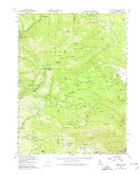
1958 Map of Jonesville
USGS Topo · Published 1974About this map
Jonesville serves as a central landmark in this high-elevation survey of the northern Sierra Nevada, where the headwaters of the West Branch Feather River and Butte Creek descend from the ridges. The landscape is defined by its mid-century ranching and mining infrastructure, featuring remote outposts like Ruffa Ranch, Baccala Ranch, and Lemm Ranch. To the south, the Philbrook Reservoir and various mountain mines, including the Sky High Mine and Morris Mine, indicate the region's historical reliance on water management and mineral extraction.
Find a feature on this map
114 named features on this map. Tap any name to fly to it.
Don’t see what you’re looking for? This feature index may not catch every label — zoom into the map to look around manually.
Map Details
Editions of this 1958 Jonesville Map
4 editions found


Other maps of this area

1886 · Lassen Peak
USGS Topo · 1:250,000

1888 · Bidwell Bar
USGS Topo · 1:125,000

1891 · Bidwell Bar
USGS Topo · 1:125,000

1891 · Chico
USGS Topo · 1:125,000

1892 · Lassen Peak
USGS Topo · 1:250,000

1893 · Chico
USGS Topo · 1:125,000

1893 · Bidwell Bar
USGS Topo · 1:125,000

1894 · Lassen Peak
USGS Topo · 1:250,000

1895 · Bidwell Bar
USGS Topo · 1:125,000

1895 · Chico
USGS Topo · 1:125,000