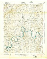
1939 Map of Joppa
USGS Topo · Published 1939About this map
The Holston River winds through the southern portion of this landscape, carving deep oxbows like Shoe Bend and Vineyard Bend along the boundary of Grainger and Jefferson counties. This 1939 Tennessee Valley Authority survey captures a rural Appalachian economy defined by decentralized general stores and community focal points such as Massengill Mill and Peeks Mill. The presence of CCC Camp No 8 and the Buffalo Springs Fish and Game Preserve reflects the era's conservation efforts and public works projects near the community of Tampico.
Find a feature on this map
63 named features on this map. Tap any name to fly to it.
Don’t see what you’re looking for? This feature index may not catch every label — zoom into the map to look around manually.
Map Details
Editions of this 1939 Joppa Map
This is the sole edition of this map. No revisions or reprints were ever made.
Other maps of this area

1883 · Morristown
USGS Topo · 1:125,000

1893 · Morristown
USGS Topo · 1:125,000

1895 · Morristown
USGS Topo · 1:125,000

1897 · Maynardville
USGS Topo · 1:125,000

1900 · Maynardville
USGS Topo · 1:125,000

1935 · Luttrell
USGS Topo · 1:24,000

1935 · Mascot
USGS Topo · 1:24,000

1935 · Tate Springs
USGS Topo · 1:48,000

1935 · Straw Plains
USGS Topo · 1:48,000

1935 · Joppa
USGS Topo · 1:24,000