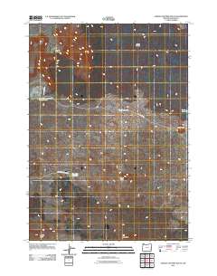
2011 Map of Jordan Craters South
USGS Topo · Published 2011About this map
Jordan Craters and its surrounding volcanic formations dominate this portion of Malheur County, showcasing a landscape defined by past geothermal activity. The area is marked by numerous distinctive landforms such as Biscuit Butte, Clarks Butte, Saddle Butte, and Lava Butte, which rise above the sagebrush-covered plains. Water management in this arid environment is evident through a series of engineered catchments including Lava Reservoir, Dry Lake Reservoir, and Mud Lake Reservoir Number Two, reflecting the region's reliance on stored runoff for ranching and wildlife. Primitive roads like W Cow Creek Rd and Biscuit Butte Rd provide the only passage through this desolate corner of eastern Oregon, connecting various seasonal lakes like Mud Lake and Batch Lake with the prominent volcanic features of the Jordan Craters field.
Find a feature on this map
14 named features on this map. Tap any name to fly to it.
Don’t see what you’re looking for? This feature index may not catch every label — zoom into the map to look around manually.
Map Details
Editions of this 2011 Jordan Craters South Map
This is the sole edition of this map. No revisions or reprints were ever made.
Other maps of this area

1955 · Jordan Valley
USGS Topo · 1:250,000

1955 · Boise
USGS Topo · 1:250,000

1957 · Jordan Valley
USGS Topo · 1:250,000

1958 · Boise
USGS Topo · 1:250,000

1958 · Jordan Valley
USGS Topo · 1:250,000

1962 · Boise
USGS Topo · 1:250,000

1969 · Jordan Craters South
USGS Topo · 1:24,000

1969 · Mc Cain Creek
USGS Topo · 1:24,000

1969 · Jordan Craters North
USGS Topo · 1:24,000

1969 · Cow Lakes
USGS Topo · 1:24,000