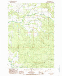
1985 Map of Jordan
USGS Topo · Published 1985About this map
Thomas Creek and Jordan Creek define the drainage patterns of this Linn County landscape, where small agricultural and forestry settlements like Jordan and Bilyeu are connected by a network of timber-truss spans. The presence of Jordan Bridge, Hannah Bridge, and Larwood Bridge highlights a reliance on these critical crossings over the region's numerous waterways. The terrain is dominated by the steep slopes of Rogers Mountain to the west, giving way to the complex valleys of Burmester Creek and Neal Creek. In the southern portion of the map, the Roaring River Fish Hatchery sits near the confluence of the Roaring River and Crabtree Creek, marking a significant site of local resource management. This area, captured just before the mid-1980s, shows the persistence of rural life with small cemeteries, borrow pits, and mills scattered among the timbered ridges.
Find a feature on this map
25 named features on this map. Tap any name to fly to it.
Don’t see what you’re looking for? This feature index may not catch every label — zoom into the map to look around manually.
Map Details
Editions of this 1985 Jordan Map
This is the sole edition of this map. No revisions or reprints were ever made.
Other maps of this area

1921 · Lebanon
USGS Topo · 1:62,500

1922 · Lebanon
USGS Topo · 1:48,000

1924 · Lebanon
USGS Topo · 1:62,500

1925 · Stayton
USGS Topo · 1:62,500

1940 · Lebanon
USGS Topo · 1:62,500

1941 · Stayton
USGS Topo · 1:62,500

1944 · Lebanon
USGS Topo · 1:62,500

1951 · Lyons
USGS Topo · 1:62,500

1951 · Snow Peak
USGS Topo · 1:62,500

1953 · Salem
USGS Topo · 1:250,000