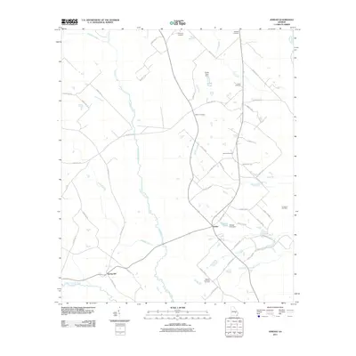
2011 Map of Jordan
USGS Topo · Published 2011About this map
The Little Ocmulgee River and the Oconee River frame a landscape defined by meandering watercourses and rural family homesteads in this part of Georgia. Centered on the community of Jordan, the area is networked by a dense web of county roads and highways that connect scattered settlements like Spring Hill to local landmarks and agricultural tracts. This 2011 survey reveals a high concentration of family and community burial grounds, including the Browning Cemetery, Starlight Cemetery, Clark Cemetery, and the Spencer and Baker Cemetery, which offer significant value for genealogical research. The presence of Smith Pond Dam and Stewart Pond Dam along the tributaries of Alligator Creek and Lotts Creek suggests a managed water system supporting the local environment. Smaller drainages like Camp Creek, Eddards Creek, and Crooked Creek further divide the terrain, illustrating the intricate drainage patterns of the coastal plain region.
Find a feature on this map
57 named features on this map. Tap any name to fly to it.
Don’t see what you’re looking for? This feature index may not catch every label — zoom into the map to look around manually.
Map Details
Editions of this 2011 Jordan Map
This is the sole edition of this map. No revisions or reprints were ever made.
Other maps of this area

1953 · Waycross
USGS Topo · 1:250,000

1957 · Macon
USGS Topo · 1:250,000

1958 · Macon
USGS Topo · 1:250,000

1958 · Waycross
USGS Topo · 1:250,000

1964 · Macon
USGS Topo · 1:250,000

1970 · Scotland
USGS Topo · 1:24,000

1970 · Glenwood
USGS Topo · 1:24,000

1970 · Alamo
USGS Topo · 1:24,000

1970 · Mount Vernon
USGS Topo · 1:24,000

1970 · Uvalda
USGS Topo · 1:24,000