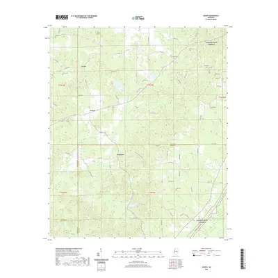
2020 Map of Joseph
USGS Topo · Published 2020About this map
The Natchez Trace Parkway cuts diagonally across this landscape where the borders of Attala, Leake, and Madison counties meet. This modern survey reveals a region defined by its rural cemetery network, including Hill Springs Cem, Ellington Cem, and Harmon Cem, which serve as vital markers for local family history and genealogy. The terrain is a complex web of small waterways, with Bolatusha Cr and Bisland Bayou draining the wooded lowlands near the Yockanookany River. Small settlements such as Joseph and Zemuly are connected by a grid of county roads, while the community of Bolatusha sits near the crossing of Shiloh Rd. The map illustrates the persistence of traditional land divisions, showing how early township and range lines continue to dictate the placement of roads and properties in this part of Mississippi.
Find a feature on this map
75 named features on this map. Tap any name to fly to it.
Don’t see what you’re looking for? This feature index may not catch every label — zoom into the map to look around manually.
Map Details
Editions of this 2020 Joseph Map
This is the sole edition of this map. No revisions or reprints were ever made.
Other maps of this area

1953 · Meridian
USGS Topo · 1:250,000

1953 · West Point
USGS Topo · 1:250,000

1957 · Meridian
USGS Topo · 1:250,000

1958 · West Point
USGS Topo · 1:250,000

1962 · Thomastown
USGS Topo · 1:62,500

1963 · West Point
USGS Topo · 1:250,000

1964 · Camden
USGS Topo · 1:24,000

1964 · Newport
USGS Topo · 1:24,000
1964 · Durant
USGS Topo · 1:24,000

1964 · Kosciusko
USGS Topo · 1:24,000