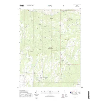
2020 Map of Joseph Peak
USGS Topo · Published 2020About this map
The Pahvant Range dominates this portion of the Fishlake National Forest, where the high-altitude divide between Sevier and Millard counties defines the landscape. Centered on Joseph Peak, the topography is a complex network of deep drainages and flat-topped benches, including Al Gay Flat and the high Grass Valley. Water management is evident through features like Chokecherry Reservoir and the Gardner Hollow Reservoirs, which capture runoff from peaks such as Indian Peak and Bald Hill. This 2020 survey details a region defined by its trail systems, notably the Paiute (D-1) route and various numbered trails that navigate through Sam Stowe Canyon and over Coalbed Pass. The map reveals the intricate watershed of Corn Creek and Indian Creek, providing a contemporary record of forest access and land use in this part of central Utah.
Find a feature on this map
73 named features on this map. Tap any name to fly to it.
Don’t see what you’re looking for? This feature index may not catch every label — zoom into the map to look around manually.
Map Details
Editions of this 2020 Joseph Peak Map
This is the sole edition of this map. No revisions or reprints were ever made.
Other maps of this area

1885 · Beaver
USGS Topo · 1:250,000

1932 · Sevier
USGS Topo · 1:62,500

1935 · Sevier
USGS Topo · 1:62,500

1940 · Monroe
USGS Topo · 1:62,500

1944 · Monroe
USGS Topo · 1:62,500

1953 · Richfield
USGS Topo · 1:250,000

1958 · Richfield
USGS Topo · 1:250,000

1961 · Richfield
USGS Topo · 1:62,500

1962 · Fillmore
USGS Topo · 1:62,500
1980 · Antelope Range
USGS Topo · 1:24,000