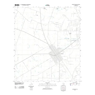
2010 Map of Jourdanton
USGS Topo · Published 2010About this map
Jourdanton serves as the focal point of this South Texas landscape, where the town's dense residential grid contrasts with the sprawling ranch and farm lands of Atascosa County. The geography is defined by a network of seasonal watercourses, including the Atascosa River in the northeast and numerous creeks such as Salt Branch, Goose Creek, and Stancel Creek. Water management is evident through local landmarks like Scheidt Lake, Bonita Reservoir, and Palmer Ranch Lake, each supported by dedicated dams. Transportation and local aviation are central to the area's layout, with the Pleasanton Municipal Airport and the Maurice Dauwe Farm Airport situated near the town. For those tracing family history, the Hilburn Cemetery remains a significant local landmark. The map reveals a transition from a centralized community to a rural economy interconnected by an extensive system of county roads and named lanes like Old Pearsall and Rodriguez Ln.
Find a feature on this map
61 named features on this map. Tap any name to fly to it.
Don’t see what you’re looking for? This feature index may not catch every label — zoom into the map to look around manually.
Map Details
Editions of this 2010 Jourdanton Map
This is the sole edition of this map. No revisions or reprints were ever made.
Other maps of this area

1953 · Crystal City
USGS Topo · 1:250,000

1954 · San Antonio
USGS Topo · 1:250,000

1955 · Crystal City
USGS Topo · 1:250,000

1956 · Pleasanton
USGS Topo · 1:62,500

1956 · Jourdanton
USGS Topo · 1:62,500

1957 · San Antonio
USGS Topo · 1:250,000

1961 · Crystal City
USGS Topo · 1:250,000

1964 · Leming
USGS Topo · 1:24,000

1968 · Crystal City
USGS Topo · 1:250,000
1968 · Jourdanton
USGS Topo · 1:24,000