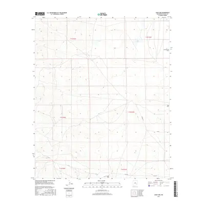
2017 Map of Juan Lake
USGS Topo · Published 2017About this map
Juan Lake and Antelope Lake sit at the center of this arid landscape in Chaves County, where the topography is defined by ephemeral drainage systems and livestock-range infrastructure. The terrain is characterized by broad depressions and natural catchment basins, with water movement dictated by features like Thirteenmile Draw and Zubi Draw. Rural transit through this section of the Pecos Valley region relies on a network of established ranch roads, including Zubi Rd, Co Rd 144, and Chesser Rd. These routes connect dispersed points across the townships of T12S through T14S, reflecting the low-density land use typical of New Mexico's southeastern plains. Small-scale topographical variations, such as Made Draw, illustrate the subtle but essential watercourses that have shaped historical grazing patterns and property boundaries in this high-desert environment.
Find a feature on this map
15 named features on this map. Tap any name to fly to it.
Don’t see what you’re looking for? This feature index may not catch every label — zoom into the map to look around manually.
Map Details
Editions of this 2017 Juan Lake Map
This is the sole edition of this map. No revisions or reprints were ever made.
Other maps of this area

1949 · Hondo Reservoir
USGS Topo · 1:24,000

1949 · Peters Lake
USGS Topo · 1:24,000

1949 · Roswell South
USGS Topo · 1:24,000

1949 · Juan Lake
USGS Topo · 1:24,000

1955 · Hackberry Ranch
USGS Topo · 1:24,000

1955 · Kincaid Ranch
USGS Topo · 1:24,000

1955 · Roswell
USGS Topo · 1:250,000

1956 · Diamond A Ranch
USGS Topo · 1:24,000

1958 · Roswell
USGS Topo · 1:250,000
1959 · Hackberry Ranch
USGS Topo · 1:24,000