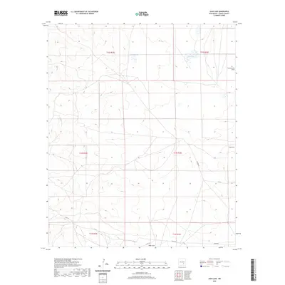
2020 Map of Juan Lake
USGS Topo · Published 2020About this map
Juan Lake and Antelope Lake punctuate this high-desert landscape in Chaves County, revealing the critical role of intermittent water sources in New Mexico's ranching country. The terrain is defined by its drainage patterns, most notably Thirteenmile Draw in the northeast and the branching paths of Zubi Draw and Made Draw further south. These features illustrate the natural hydrology of the region, where water flow is seasonal but central to the location of early land claims and routes. Local infrastructure is sparse, characterized by dirt-track connections like Zubi Draw Rd and Chesser Rd, which provide access to this open range. The map clearly delineates the township and range grid, showing how the land was partitioned into sections across t13s r23e and surrounding areas, a structure that continues to govern land ownership and use in this part of the state.
Find a feature on this map
16 named features on this map. Tap any name to fly to it.
Don’t see what you’re looking for? This feature index may not catch every label — zoom into the map to look around manually.
Map Details
Editions of this 2020 Juan Lake Map
This is the sole edition of this map. No revisions or reprints were ever made.
Other maps of this area

1949 · Hondo Reservoir
USGS Topo · 1:24,000

1949 · Peters Lake
USGS Topo · 1:24,000

1949 · Roswell South
USGS Topo · 1:24,000

1949 · Juan Lake
USGS Topo · 1:24,000

1955 · Hackberry Ranch
USGS Topo · 1:24,000

1955 · Kincaid Ranch
USGS Topo · 1:24,000

1955 · Roswell
USGS Topo · 1:250,000

1956 · Diamond A Ranch
USGS Topo · 1:24,000

1958 · Roswell
USGS Topo · 1:250,000
1959 · Hackberry Ranch
USGS Topo · 1:24,000