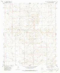
1981 Map of Juan Largo Canyon East
USGS Topo · Published 1981About this map
Corn Ranch serves as a primary landmark in this high-desert landscape of Lincoln County, where the terrain is defined by complex drainage systems and isolated water sources. Ranching infrastructure dominates the human footprint, evidenced by the strategic placement of Ingram Windmill, West Windmill, and South Windmill. These features indicate the essential reliance on groundwater for livestock in an arid environment cut by deep erosional features like Wildcat Canyon and Juan Largo Canyon. The map reveals a transition from the elevated peaks of Gyp Hill in the north down toward the broader plains of the Gallo Arroyo. While the landscape appears sparsely populated, the density of named canyons, including Little Juan Largo Canyon and South Canyon, suggests a well-traversed territory for local ranchers and land managers during the early 1980s.
Find a feature on this map
13 named features on this map. Tap any name to fly to it.
Don’t see what you’re looking for? This feature index may not catch every label — zoom into the map to look around manually.
Map Details
Editions of this 1981 Juan Largo Canyon East Map
This is the sole edition of this map. No revisions or reprints were ever made.
Other maps of this area

1954 · Fort Sumner
USGS Topo · 1:250,000

1955 · Roswell
USGS Topo · 1:250,000

1958 · Fort Sumner
USGS Topo · 1:250,000

1958 · Roswell
USGS Topo · 1:250,000

1962 · Roswell
USGS Topo · 1:250,000

1967 · North Lake
USGS Topo · 1:24,000

1967 · Chivata Canyon
USGS Topo · 1:24,000

1967 · Ramon SW
USGS Topo · 1:24,000

1979 · Fort Sumner
USGS Topo · 1:100,000
1979 · Salt Creek
USGS Topo · 1:100,000