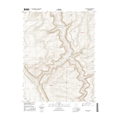
2016 Map of Juanita Arch
USGS Topo · Published 2016About this map
The Dolores River carves a deep path through Mesa County, Colorado, defining the dramatic verticality of this Western landscape. In this 2016 survey, the river is flanked by massive plateaus including Tenderfoot Mesa, Sewemup Mesa, and Calamity Mesa. The eponymous Juanita Arch stands as a prominent geologic landmark above Little Maverick Canyon, while the western edge of the map reveals the beginning of the striking Sinbad Valley geologic collapse. This map provides an essential record of the complex drainage systems that feed into the Dolores, such as Salt Cr and Blue Cr. Navigational routes are sparse, represented by specialized tracks like 11 J 10 RD and the Blue Mesa Trail, illustrating the isolation and specialized land use common in this part of the Colorado Plateau.
Find a feature on this map
25 named features on this map. Tap any name to fly to it.
Don’t see what you’re looking for? This feature index may not catch every label — zoom into the map to look around manually.
Map Details
Editions of this 2016 Juanita Arch Map
This is the sole edition of this map. No revisions or reprints were ever made.
Other maps of this area

1885 · La Sal
USGS Topo · 1:250,000

1916 · Paradox Valley
USGS Topo · 1:125,000

1922 · Paradox Valley
USGS Topo · 1:125,000

1948 · Roc Creek
USGS Topo · 1:24,000

1949 · Roc Creek
USGS Topo · 1:24,000

1949 · Juanita Arch
USGS Topo · 1:24,000

1949 · Red Canyon
USGS Topo · 1:24,000

1949 · Calamity Mesa
USGS Topo · 1:24,000

1949 · Gateway
USGS Topo · 1:24,000

1950 · Juanita Arch
USGS Topo · 1:24,000