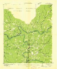
1936 Map of Judson
USGS Topo · Published 1936About this map
The Little Tennessee River and its confluence with the Tuckasegee River form the central geography of this mid-1930s survey, documenting a river system and communities before the creation of Fontana Lake. The settlements of Bushnell, Judson, Forney, and Almond appear along the riverbanks and the Southern railroad line, showing a landscape of small farmsteads, country schools like Mill Creek Sch, and local burial grounds including Monteith Cem.
Find a feature on this map
127 named features on this map. Tap any name to fly to it.
Don’t see what you’re looking for? This feature index may not catch every label — zoom into the map to look around manually.
Map Details
Editions of this 1936 Judson Map
This is the sole edition of this map. No revisions or reprints were ever made.
Other maps of this area

1886 · Knoxville
USGS Topo · 1:125,000

1891 · Cowee
USGS Topo · 1:125,000

1892 · Knoxville
USGS Topo · 1:125,000

1893 · Mt Guyot
USGS Topo · 1:125,000

1894 · Knoxville
USGS Topo · 1:125,000

1895 · Knoxville
USGS Topo · 1:125,000

1897 · Cowee
USGS Topo · 1:125,000

1901 · Knoxville
USGS Topo · 1:125,000

1907 · Cowee
USGS Topo · 1:125,000

1912 · Mt Guyot
USGS Topo · 1:125,000