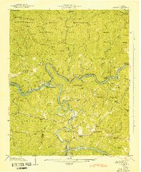
1941 Map of Judson
USGS Topo · Published 1941About this map
Judson and Almond anchor this 1941 landscape, which captures the river valley communities of the Little Tennessee just before the landscape was radically altered by the creation of Fontana Lake. The Southern Railway winds along the banks of the Little Tennessee River, passing through the remote junction at Bushnell and serving the timber and agricultural outposts of the Great Smoky Mountains foothills. This survey document details a deeply settled human geography within the Great Smoky Mountains National Park and Nantahala National Forest, including numerous family burial grounds like Woody Cem and Monteith Cem. Small rural institutions such as the Noland Creek Sch and Chamber Creek Ch appear alongside landmarks like Patterson Springs, providing a precise record of North Carolina mountain life during the early 1940s.
Find a feature on this map
117 named features on this map. Tap any name to fly to it.
Don’t see what you’re looking for? This feature index may not catch every label — zoom into the map to look around manually.
Map Details
Editions of this 1941 Judson Map
This is the sole edition of this map. No revisions or reprints were ever made.
Other maps of this area

1886 · Knoxville
USGS Topo · 1:125,000

1891 · Cowee
USGS Topo · 1:125,000

1892 · Knoxville
USGS Topo · 1:125,000

1893 · Mt Guyot
USGS Topo · 1:125,000

1894 · Knoxville
USGS Topo · 1:125,000

1895 · Knoxville
USGS Topo · 1:125,000

1897 · Cowee
USGS Topo · 1:125,000

1901 · Knoxville
USGS Topo · 1:125,000

1907 · Cowee
USGS Topo · 1:125,000

1912 · Mt Guyot
USGS Topo · 1:125,000