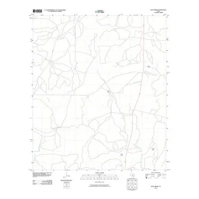
2010 Map of Julio Draw
USGS Topo · Published 2010About this map
Baker Ranch serves as a primary local landmark in this section of the Edwards Plateau, where the landscape is defined by an intricate network of seasonal drainages and creek beds. The namesake Julio Draw sits alongside Turkey Draw and West Draw, illustrating the erosional patterns of the Texas Hill Country. This 2010 survey shows a region largely defined by expansive ranching parcels, connected by the north-south artery of FM 2291. Water remains the central organizing principle of the terrain, with Gentry Creek and South Saline Creek carving paths through the limestone-based soil. Other significant watercourses such as Las Moras Creek, Big Saline Creek, and Bear Creek are documented, providing a clear picture of the watershed as it appeared in the early 21st century.
Find a feature on this map
12 named features on this map. Tap any name to fly to it.
Don’t see what you’re looking for? This feature index may not catch every label — zoom into the map to look around manually.
Map Details
Editions of this 2010 Julio Draw Map
This is the sole edition of this map. No revisions or reprints were ever made.
Other maps of this area

1954 · Llano
USGS Topo · 1:250,000

1955 · Llano
USGS Topo · 1:250,000

1956 · Llano
USGS Topo · 1:250,000

1970 · San Augustine Draw
USGS Topo · 1:24,000

1970 · Julio Draw
USGS Topo · 1:24,000
1970 · Rust Ranch
USGS Topo · 1:24,000

1970 · Brewer Hollow
USGS Topo · 1:24,000

1970 · Elm Slough
USGS Topo · 1:24,000

1970 · East Elm Creek
USGS Topo · 1:24,000
1970 · Stark Creek
USGS Topo · 1:24,000