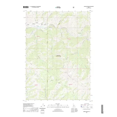
2020 Map of Jumbo Mountain
USGS Topo · Published 2020About this map
Sawtooth National Forest dominates the landscape of this high-elevation Idaho backcountry, where the Soldier Mountains and prominent peaks like Jumbo Mtn define the topography. Along the northern edge, the South Fork Boise River serves as a primary drainage corridor, accompanied by the South Fork Ranch Airport and various gulches such as Van Gulch and Big Water Gulch.
Find a feature on this map
56 named features on this map. Tap any name to fly to it.
Don’t see what you’re looking for? This feature index may not catch every label — zoom into the map to look around manually.
Map Details
Editions of this 2020 Jumbo Mountain Map
This is the sole edition of this map. No revisions or reprints were ever made.
Other maps of this area

1892 · Camas Prairie
USGS Topo · 1:125,000

1893 · Camas Prairie
USGS Topo · 1:125,000

1894 · Rocky Bar
USGS Topo · 1:125,000

1900 · Sawtooth
USGS Topo · 1:125,000

1955 · Hailey
USGS Topo · 1:250,000

1957 · Fairfield
USGS Topo · 1:62,500

1959 · Hailey
USGS Topo · 1:250,000

1962 · Hailey
USGS Topo · 1:250,000

1963 · Deer Mountain
USGS Topo · 1:24,000
1963 · Sprout Mtn
USGS Topo · 1:24,000