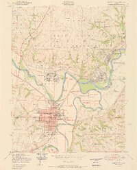
1950 Map of Junction City
USGS Topo · Published 1950About this map
Junction City serves as the focal point of this mid-century survey, situated at the strategic confluence where the Republican River and Smoky Hill River unite to form the Kansas River. The town's grid is densely detailed, featuring civic landmarks like the Court House, Municipal Building, and City Hospital. Education and local history are well-represented by Washington Grade Sch, Franklin High School, and the nearby Highland Cemetery.
Find a feature on this map
69 named features on this map. Tap any name to fly to it.
Don’t see what you’re looking for? This feature index may not catch every label — zoom into the map to look around manually.
Map Details
Editions of this 1950 Junction City Map
2 editions found
Other maps of this area

1886 · Junction City
USGS Topo · 1:125,000

1889 · Junction City
USGS Topo · 1:125,000

1889 · Parkerville
USGS Topo · 1:125,000

1894 · Junction City
USGS Topo · 1:125,000

1894 · Parkerville
USGS Topo · 1:125,000

1947 · Manhattan
USGS Topo · 1:62,500

1947 · Fort Riley
USGS Topo · 1:62,500

1950 · Keats
USGS Topo · 1:24,000

1950 · Junction City
USGS Topo · 1:24,000

1950 · Alida
USGS Topo · 1:24,000