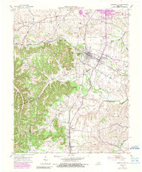
1952 Map of Junction City
USGS Topo · Published 1990About this map
The rail junction of the Southern and Louisville and Nashville railroads anchors this mid-century survey of the Bluegrass region. In Junction City, the tracks intersect near the local post office and business district, while neighboring Shelby City and the rural community of Wilsonville sit to the west and east. The landscape is defined by the transition from the rolling drainage of the Salt River and Clarks Run in the north to the prominent knobs of the south. High points like Pine Knob and Berger Knob overlook a network of country roads connecting landmarks like Catholic Ch and Goodall Airfield. Genealogists will find a variety of family-named burial sites, including Pruitt Cem and Givens Cem, alongside remote settlements like Milledgeville and Moreland near the county lines.
Find a feature on this map
37 named features on this map. Tap any name to fly to it.
Don’t see what you’re looking for? This feature index may not catch every label — zoom into the map to look around manually.
Map Details
Editions of this 1952 Junction City Map
2 editions found
Other maps of this area

1905 · Harrodsburg
USGS Topo · 1:125,000

1950 · Bryantsville
USGS Topo · 1:24,000

1952 · Perryville
USGS Topo · 1:24,000

1952 · Ellisburg
USGS Topo · 1:24,000

1952 · Halls Gap
USGS Topo · 1:24,000

1952 · Hustonville
USGS Topo · 1:24,000

1952 · Danville
USGS Topo · 1:24,000

1952 · Bryantsville
USGS Topo · 1:24,000

1952 · Stanford
USGS Topo · 1:24,000

1952 · Junction City
USGS Topo · 1:24,000