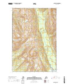
2017 Map of Juneau C-5 SW
USGS Topo · Published 2017About this map
Glacier Bay National Park dominates the interior of this coastal Alaskan landscape, where the interplay between glacial runoff and tidal inlets is clearly defined. The terrain is characterized by the parallel paths of the Bartlett River to the west and the Excursion River to the east, both carving through the high elevations of the surrounding ranges before descending toward the coast. In the southeast corner, the freshwater flow of the Excursion River meets the saltwater of Excursion Inlet, a geographic relationship critical to the area's historical role in fishing and maritime transport. The absence of roads or permanent structures reflects the preserved status of the land, highlighting the topographic isolation and natural drainage patterns that have shaped this portion of the Hoonah-Angoon Census Area.
Find a feature on this map
10 named features on this map. Tap any name to fly to it.
Don’t see what you’re looking for? This feature index may not catch every label — zoom into the map to look around manually.
Map Details
Editions of this 2017 Juneau C-5 SW Map
This is the sole edition of this map. No revisions or reprints were ever made.
Other maps of this area

1948 · Juneau C-5
USGS Topo · 1:63,360

1948 · Juneau B-6
USGS Topo · 1:63,360

1948 · Juneau C-6
USGS Topo · 1:63,360

1948 · Juneau B-5
USGS Topo · 1:63,360

1950 · Juneau C-6
USGS Topo · 1:63,360

1950 · Juneau B-5
USGS Topo · 1:63,360

1951 · Juneau
USGS Topo · 1:250,000

1962 · Juneau
USGS Topo · 1:250,000
2015 · Juneau B-5 NW
USGS Topo · 1:25,000
2015 · Juneau B-6 NE
USGS Topo · 1:25,000